© Ian Huyton

© Ian Huyton

© Ian Huyton

© Ian Huyton

© Ian Huyton

© Ian Huyton

© Ian Huyton

© Ian Huyton

© Ian Huyton


Aiguille de Venosc Hike
A long walk taking in two scenic lakes and a striking mountain peak
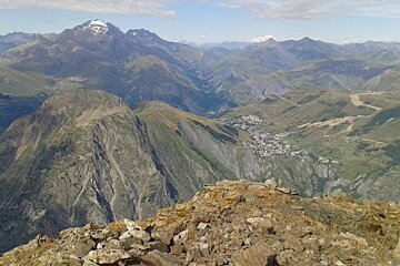
At 2,830m, this rocky pyramid would dominate the view from Les Deux Alpes were it not for its larger neighbour, La Muzelle.
From certain points on the main street it's the highest point you can see, and its sheer sides certainly give it an imposing aspect. The summit offers fantastic views back into Les Deux Alpes.
Starting point: Venosc gondola bottom station.
The most popular route to the summit is via the Col du Vallon, which is not difficult but it does feel exposed. From here an airy ridge leads to the top. Our suggested route follows a loop taking in the Muzelle and Lauvitel lakes as well as the col and the peak. The peak itself tends not to be too busy, but the two lakes can attract the crowds on a hot summer day.
From Les Deux Alpes, you can either take the Venosc gondola or drive to the starting point in Venosc. At the gondola station, cross the main road and follow the signs for the Adventure Park. The track will take you down to a bridge over the River Veneon. Cross this and take the path on the left into the woods. Pass the Adventure Park and stay on the path until you reach a clearing with a bridge to your left. Do not cross this bridge but bear right and stay on the path following signs for Lac de la Muzelle and Refuge de la Muzelle. This takes you up wooded hillsides before climbing a long valley to reach the refuge and lake. Take a moment here to admire the view, and perhaps eat something at the refuge.
Skirt rightwards around the lake until you see a path leading off to the right. This is where you will leave most other hikers behind. Follow this up ever steeper mountainsides until you reach the Col du Vallon. From here, turn right and follow the airy ridgeline to the summit with its jaw-dropping views into the valley and across to Les Deux Alpes.
Retrace your steps to regain the Col du Vallon. The shortest route back from here would be to return by the same route. For our suggested itinerary though, you should turn right to descend on the other side of the col. Go down carefully until you arrive at the northern end of Lac Lauvitel. This is a very popular swimming and picnic spot. The next couple of kilometres are likely to be busy as you mix with the crowds walking to the lake and back.
After the lake, follow the path down to La Danchere. This little village has a gîte and a buvette where you can stop for sustenance. Follow the road out of the village for a few minutes looking for a path on the right. This descends gradually to the river which you can follow back to Venosc.
Worth knowing
You could park in La Danchere instead of Venosc and start with the woodland and riverside track to warm up. If you have two cars in the party you could leave one at La Danchere and one in Venosc to save three tired kilometres at the end of the walk.
Watch out for
The last gondola from Venosc to Les Deux Alpes is at 20:00 in summer, so make sure you are back at the lift station in time.
Who should go
Fit, experienced hikers with a head for heights.
What to bring
IGN 3336ET map is recommended. You will need lift-passes or pay per person to use the Venosc gondola. Parts of the walk are a long way from shelter so take suitable spare clothing in case the weather changes.
Where to lunch
Refuge de la Muzelle is a nice place to buy lunch, both lakes are pleasant picnic spots, and there are a buvette and gîte in La Danchere towards the end of the walk.